Geoscientist Justin Lindeman manages Haley & Aldrich’s Unmanned Aerial System (UAS) or drone mapping service. Justin and his team of geophysicists and scientists, including Jennifer Pfau-Flores, Sydney LaMothe, and Marina Marcelli, configure these systems to carry payloads of imaging equipment, such as high-definition cameras, LiDAR systems, or global navigation satellite systems (GNSS): the umbrella term for satellite systems that include GPS — which enables them to survey sites on the ground in a matter of minutes. The team also manages airspace restrictions and approvals and helps clients interpret and apply the data they capture.
Justin often advises people under intense stress, providing emergency responses to disasters that have included the devastating Lahaina fire in Maui and mudslides that threaten whole neighborhoods in California. “It can be emotional,” says Justin, “but it helps to know that there are so many people around to help. And that we can contribute by solving the technical problems.”
What are the advantages of UAS surveys?
Safety is a major one: we can map out the full extent of, say, a mudslide debris flow while keeping ourselves far away from any potential hazards still on-site. We can also get a much better perspective of sites. For example, we surveyed a public road that collapsed after some of California’s major storms a few years ago. The damage abutted private property that we couldn’t access, and it was still a very dangerous area. But we could get very quick results by using a UAS to map it.
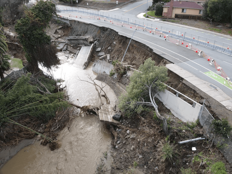
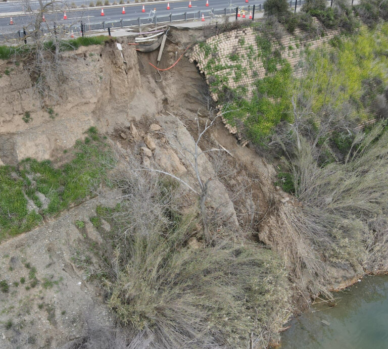
Two examples of geohazards that resulted from severe storm systems in the San Francisco Bay area in early 2023. An overwhelmed San Leandro Creek caused an embankment failure beneath A Street in Hayward (left). What started as a sinkhole developed into an embankment failure in Pleasanton (right).
That example points to another big advantage, which is efficiency. UAS surveys generate images of even large or hard-to-access sites in minutes. And we can repeat the results, which is very important. For example, a client asked us to monitor a sea wall in Santa Cruz, California, to gauge damage during the stormy season a few years ago. Instead of having multiple people trek the length of the seawall, stop at set intervals, then take photos and notes, we programmed a UAS to take photos at the precise locations. This took about 20 minutes each time we checked the wall vs. half a day when we did it manually — and it delivered a more high-quality product for analysis, interpretation, and decision-making.
All this adds up to cost savings. We’re saving time in the field and on safety measures and can spend our time advising clients on how to apply the data.
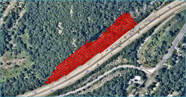
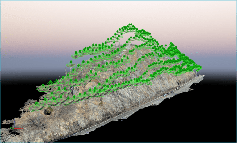
An example of a UAS terrain tracking flight model from a New Jersey project. Terrain tracking flights greatly improve model results, as can be seen in this point cloud video.
What kinds of projects do clients rely on UAS mapping for?
A lot of what we do falls into either emergency response or hazard planning and readiness.
Again, when heavy rains inundated California’s Bay Area a few winters ago, there simply weren’t enough emergency crews to go out and survey every disaster. So as soon as we could get clear enough skies, we could do all the imaging and gather data on structural damage when needed. We helped a wastewater treatment plant near the city of Monterey, where the Salinas River overflowed and basically drowned out the wastewater treatment plant. We could tell them the minute that the flooding breached the plant so they could communicate with the appropriate agencies and respond.
When it comes to bigger-scale hazard management, we’ve advised multiple GHADs [geologic hazard abatement districts, which essentially pool neighborhood money to address geologic hazards]. During the major storms, we helped a GHAD that had roughly 300 slope failures — mainly debris flows and landslides — occur within their boundaries, which was incredibly devastating for them. They only had three people on staff, and it would have taken them months to understand the extent of the hazards. With a UAS, we could identify all 300 geohazards within a few weeks, giving them a complete inventory of what had occurred within their boundaries.
The video above shows an emergency landslide repair in San Ramon, California. A fault running through the site created a wide shear zone, helping facilitate landslide movement.
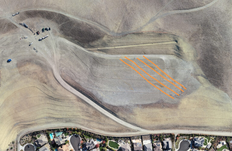
The image shows the completion of the phase 1 repair and delineates leaching sand beds (orange lines).
This map is best viewed on desktop. Use the scroll wheel on your mouse to zoom in and out, left click to rotate the view, and right click to reposition your perspective. Find information on the slide on the USGS website.
A point cloud viewer of the May 2017 Mud Creek landslide along Highway 1 in California.
How does your skill set reflect bigger shifts in science and engineering?
I initially wanted to get into earthquake modeling, and not necessarily anything related to programming. But for my research in grad school at UC Davis, I built my own computer programs and modeling scenarios. So I gained a really intense background in programming. I started my first job as a GIS specialist, and because I had that background, the company asked me to help recover data that they had lost in a breach that had just happened. They had just started developing their drone program, and they said, “Hey, if you could help with that so quickly, you could probably help us out with drones.”
I think that now, we’re seeing a new generation of geoscientists who, like me, have a knowledge of both geology/geophysics and computer programming that allows them to span and innovate in different sectors. UAS is just a tool, but if you know how to program, you can hack it and make it more useful to what you do versus relying on out-of-the-box applications. You can tailor it to an industry or a use case. We don’t have to be limited by what’s available — we can make our own things.

Published: 7/10/2024